 |
Montserrat - the Soufriere Hills Volcano |
May 23, 2011 Monday
I’ve always been intrigued by Montserrat, having read blogs by other boaters who talk about the volcanic ash covering their boat when this active volcano spews forth and how many months it took to get rid of it all from within. We had not planned to stop, but realizing we had a perfect weather window, with perfect wind direction and no seas, we altered our plans and shorted our course.
We passed by Redonda, a tiny rock island about one mile long and 1,000 feet high. It has no real claim to fame - just a big rock sticking up in the Caribbean Sea. One cannot anchor there nor climb about as it is far to dangerous and uninhabitable. Long ago phosphate was mined out of here but was abandoned some years later. One of the hurricanes destroyed all signs of life and nothing has ever been rebuilt. There is a KINGDOM of Redonda - or perhaps WAS a Kingdom of Redonda in the 1800’s. An English writer apparently badgered the King of England into giving him a title and that is what he got. He handed it down to friends, who continued the tradition, calling themselves KING. Finally in 1998, the latest King tired of it all and a local artist from Antigua claimed the title, saying he was ‘on the short list as he was only 5 feet tall’.... and so it goes on and on and on and on.....Fun stuff to read while cruising past toward Montserrat further south.
Montserrat’s main anchorages are now Little Bay & Cars Bay, side by side and both of which are far from the volcano & considered safe. Safe, that is, as long as there are no northerly swells which will make the anchorages horrible and impossible to dink to shore. Little Bay will also be very uncomfortable in the regular strong NE trade winds as the easterly swell rounds the corner. When we return in the winter, the winds would probably no longer permit anchoring safely.
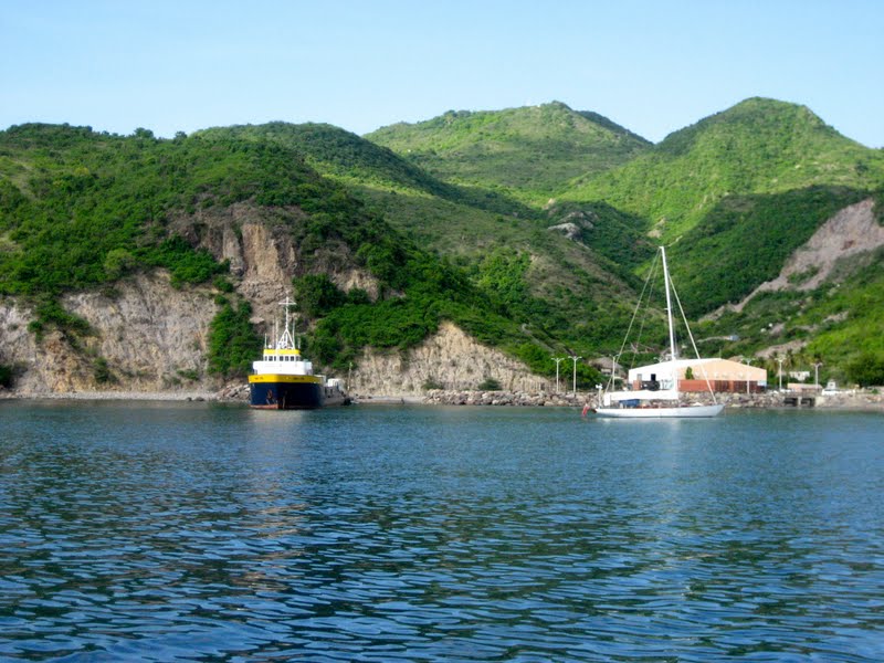
Dropping the hook in Little Bay, a bit nervous about the reef to the south of us and trying to stay out of the channel that barges and fisherman utilize, we settled in among the six or so boats already there.
 |
| Finally Fun @ anchor in Little Bay |
It didn’t take long for the Police Boat to zoom out to us - “Sorry, so sorry, but we have bad news for you. You must move your boat as you are in the channel (remember, the channel is NOT marked - it was hard to figure out where it was) and we expect a barge or two over the next day and night.” Oops, okay. The only spot left was closer to that reef than we would have liked, but we took it anyway.....we like a LOT of room but on a day like this, a little room will do versus NO room.
 |
| Joe, a/d/a 'Avalon' showing us BEFORE photos |
Immediately hailed on the VHF as soon as our hook was dropped, "Avalon", a local tour/taxi driver offered to take us to see the volcano & the island tomorrow for $130. We were impressed by his salesmanship. Right after that, we received a VHF call from “Wildcat” a catamaran we’d been chatting with via VHF since departing St. Maartin the day before. Meeting Chris and Pam from Wildcat as we cleared into Montserrat, plans were quickly made and we booked Avalon to take the 4 of us on the tour tomorrow for the same $130 quoted.
I heard snorkeling is fairly decent here. As soon as we were settled in & had cleared Customs & Immigration, I talked Andy into taking me around into Rendezvous Bay, just above us and letting me jump out of the dingy to check it out. Not so good - mostly rock that slid off the mountain above. I swam for a bit before returning to the dingy where Andy patiently sat waiting for me.
May 24, 2011, Tuesday Touring Montserrat - the Soufriere Hills Volcano
 |
| Soufriere Hills Volcano on Montserrat |
What an awesome day! This small, 40 square mile island was actually settled by the IRISH who arrived from St. Kitts in 1630, establishing small farms growing a mix of crops. They were unable to survive economically and most returned to Ireland - but not before declaring this place The Emerald Isle - just like Ireland. Traces of the Irish influence are still found on the island today. Names such as O’Brian, Ryan, Galloway etc. are still in use here by the descendants, as are some traditional Irish meals and foods.
This fairly small, pear shaped island is now divided into two zones because of the volcanic activity and so very different from each other.
As we cruised from the North into Little Bay, we saw lush green vegetation on the mountains and some typical colorful Caribbean houses.
 |
| Note the slash of dirt - slides from the spewing volcano |
We could see the Soufriere Hills volcano spewing steam from a crater and smaller columns of steam rising to the clouds around that in the distance.
The southern part of the island is mostly gray, brown, no vegetation and what looks like mud slides abounding. There are signs on some of the roads to GO NO FURTHER and gates are up.
This island, until the first eruption in 1995, was thriving. About 11,000 lived here, farming, fishing or working in the tourist industry. Many Americans and Canadians had lovely second homes here. Boom, without warning, it erupted, destroying Plymouth, the Capitol city in the south.
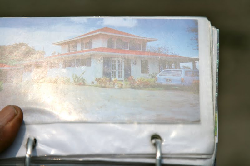
 |
| Plymouth before - note the long dock |
 |
| Plymouth AFTER - Note the shorter dock - land filled in |
 |
| Plymouth - town is gone |
Much of the surrounding area became nearly uninhabitable due to the ash and dust that was a constant presence, but people remained in ‘safe zones’ nearby. Then in 2003, the crater dome collapsed. People thought that meant Soufriere was going back to sleep and began reopening the area, repairing and rebuilding Plymouth and the surrounding areas and physically moving back in. Unfortunately, in 2006 and again in 2008, more eruptions occurred re-destroying much of the rebuild. If it wasn’t re-destroyed then, it is continuing to be destroyed now because of the ash, dust and sand that washes down continually.
 |
| View cruising southward PAST Plymouth & southern end of Montserrat |
 |
| Looking at 2nd story of a home |
 |
| This is debris - mud/sand slides |
 |
| Someone's home |
 |
| Traveling on a golf course |
 |
| Total destruction |
There is now a large NO GO exclusion zone that covers about 2/3 of the island. About 8,000 of 11,00 people living here finally left, going to other islands or to England (this is British and England helped them) many leaving their homes forever with nothing and broke, as jobs dried up and businesses failed.
Some had insurance; some did not and those that did often found themselves without recovering much, due to insurance ‘loopholes’. Jobs, everything gone.
Today, there is an Observatory from which scientists work, trying to stay one step ahead of another eruption. There are formal volcano alerts providing information as to potential danger increasing or decreasing and what the winds are doing to the ash spewing forth, etc. (Log onto Montserrat.com or www.doyleguides.com or call the Montserrat Observatory at 664-491-5647 for information.) Of interest to boaters reading this, the exclusion zone extends some 2 miles offshore on the southern side -- the beach has been extended by the slides, ash and dust and shoaling continues to occur.
 |
| The Observatory |
Avalon a/k/a Joe Phillips (664-492-1565 or VHF 16 Avalon) is recommended in Chris Doyle’s guide and cited elsewhere as a very professional guide. We agree! His tour I think is twice the price of another we met - maybe - not certain, but I noticed we were gone nearly twice as long as the other couple. Joe told us often that he IS the best tour guide because he knows his history, knows the volcano and has the BEFORE photos. He is a wealth of information, handing us brochures he’d prepared that covered the history, the destruction and information about volcanic terms and differences in volcanos, etc.
Best of all, he had the actual photographs of places we visited taken BEFORE the volcano.
 |
| The golf course BEFORE |
 |
| Golf course AFTER |
 |
| Driving over it all making our own road |
Looking at the photo of a beautiful home, of a golf course, of the resort and golf clubhouse before the eruption and then, standing there, in the middle of it all on a 3 story mud/dust/whatever slide that covered the golf course, covered the 3 story home up to the top roof; covered the club house to it’s top floor made a huge impact on us all. It would not have been so overwhelming had we not see the before photos. (See all my photos which include his before photos and what we saw after).
 |
| An expensive home on the golf course |
 |
| Same home, Note the roof |
 |
| All that is left of that beautiful home |
The countryside was pretty, lush, green and peaceful with goats, lambs and cattle all over the place. Learning how much we loved mangos, Joe stopped several times and helped us knock a bunch off the trees till we could barely carry any more.
 |
| Mango Tree |
 |
| Joe has the stick. Sharon can barely reach the mangos. |
Hot and hungry, we stopped at TINA’s for lunch - a great meal of locally caught fish at very reasonable prices. At Joe’s suggestion, we ordered homemade fresh Ginger Beer (not a beer). In the US and elsewhere, Ginger Beer comes in a can and is a somewhat spicy ginger ale. Here, fresh grated ginger, sugar, and I don’t know what else, but it was delightful & a real taste treat! The coconut pie, warm from the oven was a hit - freshly grated coconut straight from a tree outside made the difference.
 |
| Andy drinking the cool water from the stream |
Joe stopped along the way to have us drink out of the mountain stream, telling us 'that once you taste the water here, you will always come back'.
 |
| The cashew fruit & nut |
Amazing what one learns by traveling. Joe plucked the cashew nut from a tree. Note the nut has a fruit attached! These are two separate things: One eats the fruit, breaking off the cashew nut and peeling it. The fruit tasted a bit slimy to me and I won't become a fan. Ah, the cashew nut, on the other hand, as you all know - is delish!!!
 |
| Cashew fruit w the nut |
Returning to the boat, Chris and Pam took me snorkeling with them - leaving Andy quite happy not to have to go. We selected a different spot, off the curving mountain wall between Little Bay and Rondezvous Bay. Ah, much better as there was more coral and more fish. Curious about the ‘caves’ cut into the rock, we swam in to check it out and to see how far back the ‘cave’ went. Huh, birds in here???? A squeeking noise. OMG - not bird - BATS. Ugh hundreds of bats along the walls up high in each of these ‘caves’. Did you know one can back pedal with fins on???? Outta there in a hurry. Ugh. I could smell bat guano and wondered how much was in the water around me. GROSS.
In spite of the bats, I loved our day on Montserrat - what an great experience!
 |
| Bat Cave is behind & to the left of the large barge boat |


No comments:
Post a Comment